Alaskan Alpine Club
Random Photos... (stuff the web slave liked for some reason)
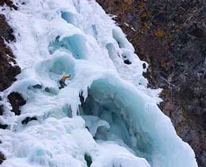
Hung Jury, Valdez Alaska. Photo by Matt Hage of HagePhoto.com. Matt has other cool photos from intriguing places.
If this is not the most picturesque frozen waterfall in the world, please send a photo of the other one.
The incessant Keystone Canyon wind blows up the narrow canyon, smack into this rock face, and up the waterfall.
Consider the available climbing routes. If you climb and survive any of your imagination, send the club a photo of you on one of the overhangs.
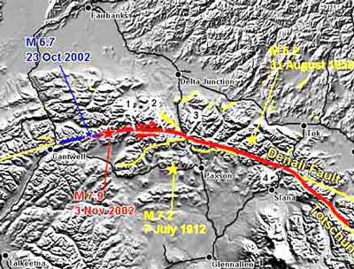
The pics below show some results of the 7.9 earthquake on 3 November 2002. They are from the Alaska State Division of Geological and Geophysical Survey (DGGS), at www.dggs.dnr.state.ak.us.
The Denali Fault, on this map, runs the length of the Alaska Range, in its center. Anchorage is off the bottom left corner, and Fairbanks at the top left quarter. The blue star shows the 6.7 earthquake on 23 October. The red star is the 7.9 shake. It was on the south side of Mt. Deborah. The two red arrows and just to their right at location number 2 is the Black Rapids Glacier, shown below, one of our play areas. We access it from the Richardson Highway at location number 3. The red and blue lines show the distance of the lateral displacement of the earthquakes. The black line highways were crinkled at the numbered locations 3 and 4. The Canwell and Gakona Glaciers are to the right of number 3. The red arrow directions show that California is slowly getting closer to Alaska, demonstrating the real reason behind global warming. Denali is off the map to the left, where we like to keep it since it attracts so many Park Service thugs. Fairbanks climbers maintain the Denali Fault to defend Fairbanks from the seething masses who live in Anchorage to the south.
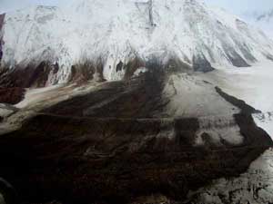
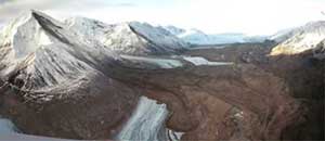
This is one of the avalanches that came off the south side of the Black Rapids Glacier, location number 2 in the above map, sweeping all the way across the glacier, about a mile. The amusing part of this photo is that while I typed that last sentence on 11 November, here in Fairbanks, we just had another earthquake that noticeably shook my computer monitor. I guess that it was about a 5.0. That has been happening a lot lately. A fresh snowfall after the earthquake covered what would otherwise show as the source of all that rock. The medial moraine in the photo is quite high, and would fool one into thinking it would stop any avalanche.
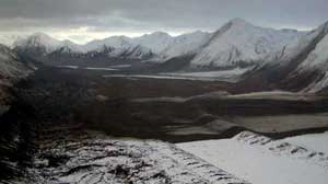
This photo is looking down the Black Rapid Glacier, showing three avalanches that swept across the glacier. They involve a distance of approximately five miles. The normal ski route up and down the glacier is in the center-left of the glacier, between the two prominent moraines in the foreground, not a place to be during a 7.9. If there were skiers in the foreground of this photo, their size would be barely distinguishable from the specks of rock. The highway is just behind the far hills at the upper left corner of the picture.
 This
photo is looking back up the Black Rapids Glacier, to the west,
at the same area shown in the previous photo from the opposite
direction. This was previously 15 miles of a broad white avenue
to the pass. The upper of the three avalanches, shown in the previous
two photos, is that thin little dark area in upper part of this
photo. The primary ski route up the glacier goes through the wider
avalanche areas in the center right. In the past, the ski down
the Black Rapids was a 15 mile glide. No few Fairbanks climbers
have often camped in this area. Imagine the environmentalist reaction
if this had been done by miners gouging the earth for molybdenum
extensively used by environmentalists. The environmentalists remain
clueless of the human position within the evolution of this planet.
The humans are the best comedy on the rock.
This
photo is looking back up the Black Rapids Glacier, to the west,
at the same area shown in the previous photo from the opposite
direction. This was previously 15 miles of a broad white avenue
to the pass. The upper of the three avalanches, shown in the previous
two photos, is that thin little dark area in upper part of this
photo. The primary ski route up the glacier goes through the wider
avalanche areas in the center right. In the past, the ski down
the Black Rapids was a 15 mile glide. No few Fairbanks climbers
have often camped in this area. Imagine the environmentalist reaction
if this had been done by miners gouging the earth for molybdenum
extensively used by environmentalists. The environmentalists remain
clueless of the human position within the evolution of this planet.
The humans are the best comedy on the rock.
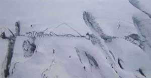
The crack splitting some old crevasses shows an approximately 20 foot lateral displacement up the center of the Canwell Glacier, . During these type earthquakes, always try to be on the side going in your direction.
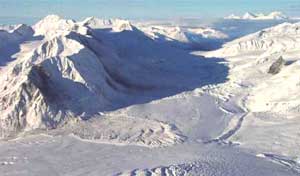
This photo, copied from somewhere, is of the west branch of the Gakona Glacier, on the Denali Fault, looking west back toward the Canwell Glacier, then Black Rapids Glacier. The two larger hills on the top right horizon are Moffit on the right and Shand on the left, with the Black Rapids Glacier under the cloud on the other side of the Richardson Highway. The top of the Gakona Glacier is Yeti Pass, partially in the sun, going over and down the Canwell Glacier. The south side of the glacier, on the left, is the side that was moving, with the results similar to the Black Rapids Glacier. Three big ones took out the entire normal ski route for access to mountains on the Gakona. Most of the shadow area is under avalanche debris. Like the Black Rapids Glacier, no few climbers have camped in the areas now under avalanche debris.
This is a hazardous planet. I recommend only a short visit, and then be quick to leave at the first indication of anything unusual. But enjoy the comedy of the humans incessantly contradicting themselves and clueless of how to ask effective questions to therefore easily resolve their self-damaging contradictions.
Climb on...
Climbing Taxes
The Club
Climbing Concepts 1
Climbing Concepts 2
Climbing Concepts 3
Club Museum
Gullible Climbers
Member Number
Mountain Rescue Fund
Wilderness Classic Race
National Park Service
Posters and Calendars
Posters 2
Events
Ice Towers
Ice Towers Web Cam
03-04 Ice Tower
04-05 Ice Tower
05-06 Ice Tower
07-08 Ice Tower1
07-08 Ice Tower2
07-08 Ice Tower3
07-08 Ice Tower4
07-08 Ice Tower5
07-08 Ice Tower6
07-08 Ice Tower7
07-08 Ice Tower8
Other Ice Towers
Links
Home