Home
LL Buchanan Lake
Lake History ....by Lynn Buchanan
 The piece of property
directly south of Sarge Hubbard Park was for many years south
of the county dump. The park was later built over the dump. It
was commonly referred to as "the hog ranch". It often
had smoke drifting across it from the smoldering pile of waste
that forms the hill in the park. As a child I went to the ranch
many times when my father, L L Buchanan, was going down to check
on the cattle he grazed on the riverbank and the sloughs that
drained into the river. The land was covered with patches of sagebrush,
wild blackberry vines and scattered Cottonwood trees. There was
an "old" man who watched over the cattle and did what
feeding was necessary. His one room cabin was one of the few in
the area. I was a rather young child at that time.
The piece of property
directly south of Sarge Hubbard Park was for many years south
of the county dump. The park was later built over the dump. It
was commonly referred to as "the hog ranch". It often
had smoke drifting across it from the smoldering pile of waste
that forms the hill in the park. As a child I went to the ranch
many times when my father, L L Buchanan, was going down to check
on the cattle he grazed on the riverbank and the sloughs that
drained into the river. The land was covered with patches of sagebrush,
wild blackberry vines and scattered Cottonwood trees. There was
an "old" man who watched over the cattle and did what
feeding was necessary. His one room cabin was one of the few in
the area. I was a rather young child at that time.
To the west of the ranch was a slough with grassy banks and cottonwoods.
On the west bank of the slough was an old house, and to the south
of it a couple of shacks. These were near the current east end
of Beech Street. I remember going into one of these former homes
with a dirt floor and rough walls, with two or three rooms, being
used for a cattle shelter. I was in junior high in Selah at the
time, and my father had me down there in the winter to cut the
cottonwood trees. That made the date as sometime in the winter
of 1942 or 1943. The trees were about a foot and a half through,
and quite tall, making quite a sight as they fell across the ice
of the pond. At the time, the hog feeding was getting into full
production.
During WW II my father had a contract to haul all the waste food
away from the Yakima Firing Center. He had a special tank truck
that a driver would drive through the rows of tents where the
Army prepared the food and fed the soldiers. The army personnel
would dump the waste food containers, "garbage cans",
into the tank at each stop. That waste food was then hauled to
the ranch where it was cooked again in a large tank and fed to
the 100-300 hogs that were fattened there for the Yakima area
butcher shops.
He also had an old dump truck with a high-sided wooden bed that
he or one of his employees would take to the Selah brewery to
pick up loads of "malt" (the spent barley from the beer
making process) to feed cattle. In addition to the malt, the truck
was used to haul waste from canneries around Yakima, to the feed
lots on the site of the current ponds just south of what is now
Sarge Hubbard Park. There were piles of peach peelings and pits,
pear culls and peelings, corn cobs, husks, and asparagus butts
from the canneries and processing plants that were more common
in Yakima at that time. The cattle and hogs wandered through their
pens to eat at will from the piles. When the gravel plant began
to expand there was some expressed irritation because the peach
pits occasionally got into the gravel, and caused it to be rejected
for construction. They had to be carefully cleared out before
starting to dig in a new area. Before L L Buchanan began hauling
the fruit waste to feed the hogs, the waste was dumped on the
county dump and covered with a layer of dirt. When the dump was
abandoned, many of the peach seeds sprouted and started growing
into trees. This was the "Peach Orchard" that was mentioned
in the book about the start of the Greenway Park operation.
The property at the east end of Beech Street was the "gravel
pit". Dad leased it to several companies over time to crush
rock and mix concrete for delivery to jobs in the Yakima area.
Shortly after I got my driver's license in 1946, I learned to
drive and dump loads of concrete on job sites. The most memorable
was taking a new larger sized truck to Vernita with a load of
concrete to pour footings among the steel towers of the switchyard
there. Just driving the truck into the switchyard caused it to
accumulate static electricity, so I was given very specific instructions
about how to touch the truck whenever I had to get in or out of
it to dump concrete.
Most of my working and driving was with the freight operation
after I first left for college in the fall of 1948 so I didn't
have much to do with the gravel and concrete operation after that
date. As a driver for the freight line I brought many loads of
cement from Seattle to Yakima, particularly from February thru
September 1952. You might say that was my finishing school in
driving a semi. Dad preferred to buy his cement in 96 pound cloth
bags in Seattle rather than pay someone else to haul it from there
to Yakima in a tank truck. I learned to back a 40' semi for a
city block down a narrow alley in Seattle and load it by hand
with the cloth bags of cement. His permit (CC55) was restricted
against carrying loads in "specialized equipment", so
the only way he could haul cement profitably was to pick up 20
ton loads in cloth bags. He would have a couple of men standing
in the back of a van clipping the wire ties on the bags and dumping
them into the hopper at the bottom of the conveyor that carried
the dry cement to the top of the silo. It was hot, dry, dusty
work. I usually had the job of using a hand truck to truck the
stacks of six or seven bags each to the back of the trailer for
the other two men to dump. My Teamster membership dated from those
days in 1952.
At that time there were no common houses in the hog ranch area.
There were some very sub-standard shacks there, even by the standards
of that era, most without water or electricity. Dad bought some
property with houses along Beech Street to the west of what is
now the Ice Arena, and rented them out, eventually reselling most
of them.
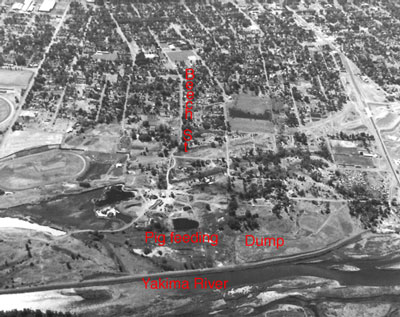
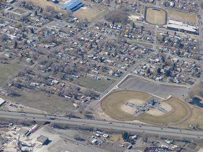
To the left is a photo of the area taken by me in 1962 from one
of Wikstrom's airplanes about six years after I returned from
the Air Force. The top of the photo is west. Beech Street is in
the left center of the photo, making a short jog to the south
near the east end, with a lot of dark trees on it's north side.
The south turn of Beech was because of one of the Sumach Park
ponds on it's north side. Part of the pond area now lies under
I-82 but the bend in Beech Street is still there just before Beech
goes under I-82. The pond was filled in during the late 1950's.
The current auto race track is on the left side of the photo,
as is the little building (a park concession stand) that predated
the current Ice Arena. The pond that lies between the concession
stand and the race track has been filled in and is partly under
I-82.
The old county dump is just west of the Yakima River in the foreground.
The L L Buchanan north property line is along the line of dark
trees extending to a county road leading west to the city. The
dump is to the north (right side of photo), and the Buchanan property
with the pig feeding area is to the south.
Valley Junk owned some of the property along the south side
of Yakima Avenue and west of the county dump property. From there
south to the north line of the L L Buchanan property was a collection
of small shacks and houses of those who could not afford to live
farther from the dump. The road south from Yakima Avenue was a
narrow rocky lane with piles of junk and garbage dumped by those
who did not want to pay the county dump fees.
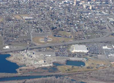
This is a photo of the same area, taken by me on 8 March 2008.
You might notice that Beech Street still has the same turn to
the south, just south of the baseball diamonds, then goes under
I-82 and enters the Central Pre-Mix Concrete plant. Yakima Avenue
is on the right side of the photo. The underpass that was under
construction in the 1962 photo is just off the right side of this
photo.
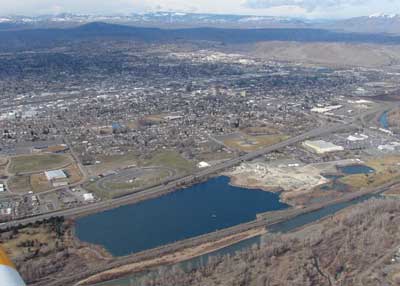
When the State decided to build I-82 thru there, L L Buchanan
had a shallow gravel pit just southeast of the ice arena. Several
other gravel pits on the site became part of the large one forming
LL Buchanan Lake. The State wanted to pay him for the property
they needed based on a description they called "sub standard
pasture and scab-land". He maintained that the property was
being mined for gravel, and at that time he was getting a set
price per yard as a royalty. He had calculated the property was
worth a certain amount based on how deep the pit would go, still
much shallower than the present pit became. By calculating the
width and depth of the right of way he arrived at the value of
the property condemned. It was an interesting condemnation case.
One of the statements made by the State was that some of the land
was a gravel pit and as a pit was worth nothing. Dad responded
that the State had some big pits in the area to the north that
were full of water at the time and he would pay the State several
thousand dollars for each one based on the State's valuation of
"nothing". He also offered to mine the right of way
property and leave them with the pit to fill as they saw fit.
They then did a lot of hedging about their testimony. I was just
back from running a photo lab for the Air Force and still have
some of the aerial photos taken then, including the black and
white one above.
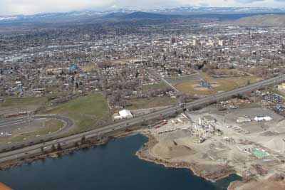
This is a close-up photo of the area, taken 8 March 2008, showing
the Beech Street underpass below Interstate-82 in the lower left
corner of the photo. Beyond I-82 is part of Kiwanis Park with
ball fields and a parking lot beyond them.
The area was initially zoned by the County many years ago as Suburban
Residential. The new zoning law at that time imposed "blanket
zoning" for many areas that were not being used for the new
zoning-described purposes. The blanket zoning was an initial expedient
for planning personnel who did not want to spend the time ascertaining
actual uses of the land, or who wanted to impose their personal
desires upon other people's property.
The Hog Ranch and area were anything except suburban residential.
The County planners ignored the county dump, the Valley Junk scrap
operation, the farming, a dairy that was north of the County Fair
Grounds, the gravel pit and cement plant. Complaints to the zoning
commission were met with County responses about initial blanket
zoning not binding any existing property use. The property owner
objected to the zoning, and did not acquiesce to any agreement
on the property use. Therefore the lawfully established prior
uses and property rights prevail.
When I was elected to the City Council there was one residential
zone for all of east Yakima to the then city limits. It had all
been zoned as R-3 because someone felt that all the single-family
homes would be removed and the area would become apartment houses.
There were several small fortunes made by developers who bought
a lot of the single family homes, removed them and merged the
property into larger areas, then sold it to the government to
build the existing low income housing units. It was then that
some of the residents petitioned to change certain areas that
were mostly single-family housing, to R-1 zoning. It was a bitterly
fought battle between home-owners and the Real Estate interests,
in front of the City Council, but the home owners eventually prevailed.
After the old county dump area was annexed by the City of Yakima,
a new city zoning plan created another typical government illusion
for everyone else's property. The plan's expectations of extensive
park land and nice residences, by government decree created a
controversy over the long established industrial and commercial
use of the properties, as a gravel and concrete operation, and
other non-residential uses of property in the area. By then a
WalMart and a large new car dealership had moved into the "residential
zone".
Economic reality left the plan where most government plans
are left.
About that time in 1997 when recoverable gravel in the combined
old gravel pits was exhausted in that area, the resulting pit
was 120 feet deep. When Central Pre Mix shut off the pumps, it
filled with water in only a few days from the surrounding water
table created by the Yakima River and the cobble stone sub strata.
Many people had ideas for what the new lake and adjacent land
should become. But none of those folks wanted to invest their
money to manifest their ideas. The land was already being used
for an economically viable concrete plant and gravel stockpiling
site serving the needs of the Yakima area.
The property owner's economically viable, annual planting of
a variety of seedling trees around LL Buchanan Lake and an adjacent
old settling pond (Swan Pond), will soon enough complement the
visual image of the Yakima Arboretum on the south boundary of
the lake, with patience, and at no cost to the taxpayers. Three
floating islands holding soil for trees were built for waterfowl
nesting habitat and visual interest. In dramatic visual contrast
to the sterilized, mowed grass monoculture around the Sarge Hubbard
Park pond just north of the property, what the park advocates
wanted for L L Buchanan Lake, the property owner maintains a diversely
vegetated waterfowl and small bird habitat not trampled by people.
It is viewable from the adjacent elevated public footpath on the
dike top along the east side of the lake. There were many expressions
of diverse public appreciation for the property owner defending
private property rights against the local government's utopian
park plan, especially among the birders in the Yakima area.
--Lynn Buchanan
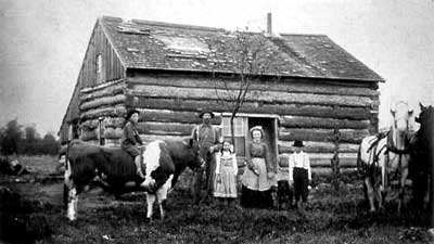
As to the matter of history, this photo is of William
Henry Buchanan and his kids at their home in Wood County Wisconsin,
about 1900. The kid on the right with the white shirt and black
hat is LL. That was shortly before he went west.
A team of horses and a bull you could ride in those days was
the current equivalent of a new Dodge Ram pickup and a Mustang
convertible. A little pricey, but the fuel cost was lower. Quiet
neighborhood too.
Imagine if his Dad had told him that some day, if he worked
as hard as he did his whole life, without vacations, and never
retired, the largest gravel pit pond in Yakima Washington would
be named for him.
Barney's Island
Betty's Island-1
Betty's Island-2
Betty's Island-3
Betty's Island-4
Betty's Island-5
Betty's Island-6
Pebbles Island
Neighbors
Swans
Birds
Trees
Trees-2
Trees-3
Lake
Links
Home